Trenchless Technology Solutions
![]()
![]()
![]()
As well as offering all the above Utility Mapping solutions we are now able to offer specialist contracting services in the field of directional drilling and all methods of trenchless technology.
Directional drilling is a method by which pipes and cables can be installed underground, without the disruption caused by trenching, such that installation can be achieved under roads, railways, rivers, airport runways etc., without any disturbance to surface structures.
Directional drilling should be used alongside the Utility Survey services Discovery Surveys offer above, offering a complete package and ensuring our clients are complying with HSG47 legislations.
Discovery Surveys Limited are able to provide a complete turnkey package, whether at a rate per metre on line work or on a fixed price basis on Specialist crossings. In many circumstances, whilst open cut methods could be employed, the extent of the disruption and inconvenience which would be caused to the business community and the public at large is such that trenchless techniques provide the practical solution. Over recent years utility companies across the UK have committed to massive programs for the installation of new and replacement mains. During this period Horizontal Directional Drilling has developed from being a marginal player to the preferred method of installation.
url clone | boohoo , Womens & Mens Clothes , Shop Online Fashion
AutoCAD and Printing Services
 As well as using AutoCAD in conjunction with all the above Utility mapping Services, Discovery Surveys can also offer an AutoCAD bureau Service to Utility Service Providers as well as to Land/Estate Agents, Architects, Developers, Builders and too many other Clients.
Within this service we provide a draughting service ranging from Utility record collation, creating new drawings from engineers sketches, to amending existing drawings which have been modified on site.
In addition to the above we can also provide prints of any requested documents at A0.
Click here to contact us for more information on our AutoCAD and Printing Services.
latest Running | Trending
Utility Record Information Search
 Obtaining record information from the relevant statutory utility providers can be confusing and most importantly time consuming. Discovery Surveys can undertakes this work on our client’s behalf, using its expertise in the Utility mapping industry to obtain the correct information.
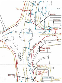
Discovery Surveys will Search for and identify all Utility Providers/Suppliers with apparatus on your site. Copies of the relevant Utility record information will be obtained by us and all relevant information about Services in a specific Survey area we will be collated and all relevant data and findings will be put onto an easy to read AutoCAD plan. Enabling easy interpretation and a utility map overlay.
We recommend all our Clients carry out a Utility record search prior to any excavation, we must also stress this should not be used as a substitute for a physical Utility Survey.
Sports Shoes | Air JordanLand and Building Surveys
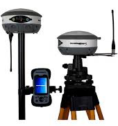
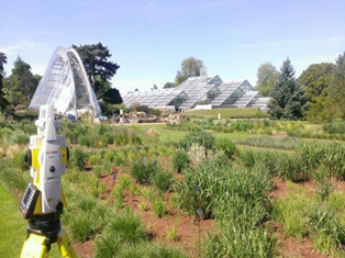
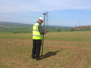 Discovery Surveys are also able to offer our clients with a Nationwide Land and Building Survey service. Using the latest technology including; GPS, one man Robotic Total Stations and laser scanning equipment we provide all our clients with exceptional survey results.
We are able to offer our clients a digital or hard copy drawing of any required Survey area. The Land survey will include all above ground features tailored to your exact requirements ranging from buildings, street furniture to Manholes and Inspection chambers. This information can also include spot heights at equal intervals throughout site to determine land elevation.
 Land Survey can be used as a standalone technique or with any Utility Mapping package or with any drainage survey package we are offering, providing a complete and comprehensive survey deliverable.
Please contact us to request a price, discuss availabilities or your survey specifications. All of our projects are fully insured and guaranteed to the original client
jordan release date | Nike sneakersGPR Survey / Radar Survey
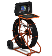
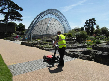
In addition to the services already offered, Discovery Surveys Ltd is able to offer a more comprehensive radar survey using our multi-channel GSSI radars, considered by many to be the most efficient and reliable Ground Penetrating Radar available on the market. This involves the operator covering all areas of site in a grid pattern recording the data on site. This data is then analyzed in detail using specialist software to find the location of underground Tanks, Cellars, Tunnels, Foundations, Voids and many more anomalies. Consecutively enabling us to produce in-depth report and plan of the features and anomalies found. GPR can be used as a standalone technique to find buried services.
The benefits
Ground Penetrating Radar Survey is able to detect metallic and non-metallic utilities, the obvious benefit been able to locate polyethylene Gas and Water pipes that are not usually detectable using other methods. We can also locate expensive to repair fibre optic cables using this technology.
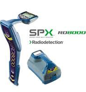
Discovery Surveys honest and open approach, means we will answer any question truthfully and advise you on the best route to take to get the survey information / results you require. We are not a company who claims GPR will locate all utilities all the time, in fact our GPR has equipment limitations like all other radars on the market. Wet and clay ground conditions will directly limit GPR penetration on any utility mapping project or anomaly survey and limit how much the radar finds but used in conjunction with our radio detection equipment you are getting the most comprehensive utility mapping survey service available.
At Discovery surveys we believe the elimination of conductive services using Electromagnetic techniques first, greatly increases the success rates and final results of the GPR survey.
It is a legal requirement to have an Ofcom license to use any GPR equipment, Discovery Surveys carries the relevant licenses to carry out all radar surveys legally.
Page 1 of 2